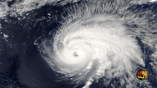
Hurricane Erin Forces Evacuations in North Carolina as Category 4 Storm Threatens East Coast

(Worthy News) – Powerful Hurricane Erin, the first major storm of the 2025 Atlantic hurricane season, continues to churn across the Atlantic as a dangerous Category 4 hurricane, prompting local states of emergency and mandatory evacuations along North Carolina’s Outer Banks.
The monster storm rapidly intensified over the weekend, exploding from a Category 1 to a catastrophic Category 5 with winds of 160 mph in under 30 hours before weakening slightly to its current Category 4 strength. As of Monday morning, Erin’s maximum sustained winds are 140 mph, according to the National Hurricane Center (NHC), which warned the system will remain a “dangerous major hurricane” through midweek.
North Carolina Evacuations Underway
Officials in Dare County issued a state of emergency and ordered mandatory evacuations for Hatteras Island, including the villages of Rodanthe, Waves, Salvo, Avon, Buxton, Frisco and Hatteras.
“Now is the time to secure property, finalize plans and evacuate with belongings,” county officials posted.
Hyde County leaders declared a similar emergency for Ocracoke Island, ordering visitors to leave Sunday night and residents to evacuate starting Tuesday morning. The North Carolina Ferry System is running full schedules to move people safely off the islands.
Authorities warned that Highway 12, the only road in and out of much of the Outer Banks, could be rendered impassable for days due to ocean overwash and flooding.
Governor Josh Stein urged residents to heed evacuation orders and prepare for coastal impacts. “North Carolinians along the coast should prepare for dangerous surf and rip currents and coastal flooding throughout the week,” he said.
Warnings for Bahamas and Caribbean
Erin’s outer rainbands are already lashing the southeastern Bahamas and the Turks and Caicos, where Tropical Storm Warnings remain in effect. The central Bahamas is under a Tropical Storm Watch. Puerto Rico, which experienced torrential rains and flooding over the weekend, reported up to 6 inches of rainfall, while the U.S. Virgin Islands recorded up to 7 inches.
The NHC cautioned that flooding and landslides remain possible in higher terrain across Hispaniola and parts of the Bahamas as the storm’s outer bands continue to dump heavy rainfall.
Impacts Along U.S. East Coast
Although the storm’s core is expected to remain offshore, its massive size will drive dangerous surf and life-threatening rip currents along the U.S. East Coast from Florida through New England this week.
The National Weather Service in Morehead City, North Carolina, has issued a High Surf Advisory and Coastal Flood Watch, forecasting waves of 7-12 feet and “significant oceanside inundation” in low-lying coastal areas.
A Storm for the Record Books
Meteorologists say Erin is already historic, joining a rare group of Atlantic hurricanes that achieved Category 5 strength before mid-August. It is the first such storm since Hurricane Milton and Hurricane Beryl in 2024.
Erin’s rapid intensification stunned forecasters: it strengthened from Category 3 to Category 5 in less than six hours on Friday. The storm later weakened as it underwent an eyewall replacement cycle but regained major hurricane strength by Sunday night.
While the hurricane’s exact long-term track remains uncertain, forecasters currently expect it to turn northward between North Carolina and Bermuda before bending northeast, staying offshore but leaving dangerous seas and coastal flooding in its wake.
💡 Did you know? One of the best ways you can support Worthy News is by simply leaving a comment and sharing this article.
📢 Social media algorithms push content further when there’s more engagement — so every 👍 like, 💬 comment, and 🔄 share helps more people discover the truth. 🙌
Latest Worthy News
If you are interested in articles produced by Worthy News, please check out our FREE sydication service available to churches or online Christian ministries. To find out more, visit Worthy Plugins.
